- REDIRECT Template:Headers and footers:Main Page
Does the Book of Mormon borrow place names from the area around Joseph Smith's home?
Questions
It is claimed that Joseph Smith is clearly the author of the Book of Mormon because many Book of Mormon place names supposedly have clear evidence of "borrowing" from geographic locations in the United States and Canada.
Examples of this include:
| Book of Mormon City |
Claimed Source |
Book of Mormon City |
Claimed Source
|
| Teancum |
Tecumseh |
Ramah |
Rama
|
| Moron |
Morin |
Ogath |
Sainte-Agathe-des-Monts, Quebec
|
| Morianton |
Moraviantown |
Angola |
Angola
|
| Onidah |
Oneida |
Kishkumen |
Kiskiminetas
|
| Jacobugath |
Jacobsburg |
Jerusalem |
Jerusalem
|
| Alma |
Alma |
Land of Lehi-Nephi |
Lehigh
|
| Shilom |
Shiloh |
Ripliancum |
Ripple Lake, Ontario
|
To see citations to the critical sources for these claims, click here
Answer
The original idea behind this proposal was that Joseph picked up these place names and locations from a map in order to create his Book of Mormon geography. However, once it becomes apparent that the locations are in the wrong place, critics who support this proposal then fall back to the claim that the locations of the names are actually unimportant.
After the geography is thrown out, we are simply left with a list of names that Joseph supposedly found on a 19th-century map. However, once it also becomes obvious that many of the place names that were allegedly located on a 19th century map did not exist at the time that Joseph was dictating the Book of Mormon, the entire theory falls apart. Of the few that actually did exist, some of these names represent extremely small, distant sites about which Joseph almost certainly could have had no knowledge.
So critics rely on names which are in the wrong place, which didn't exist during Joseph's time, and which were too small and distant for him to be aware of. The final blow to this theory is that they also overlook the Biblical source for their American "parallels," which are far more likely and plausible than giving Joseph an encyclopedic knowledge of North American place names. Even if critics insist that Joseph forged the Book of Mormon, isn't the Bible a far more likely source for these names than obscure hamlets hundreds of miles away, which did not appear on a map, and most of which didn't even exist with those names at that time?
Detailed Analysis
- Answer:
The Book of Mormon contains 345 names. The theory, proposed by Vernal Holley and posted by Mazeministries, is that 28 of these names were derived by Joseph Smith by looking at the names of places in the surrounding region, then altering the names slightly to create a map of Book of Mormon lands. The original map from which the author obtained this information included names of places which didn't even exist in Joseph Smith's time.
- Fact:
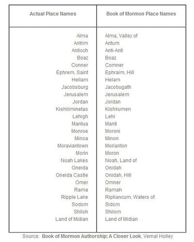
The following correspondences are listed. In order to obtain this list of parallels, a huge geographical area must be scanned: Five states and two Canadian provinces yield this list of parallels, and it gets even smaller when one actually tries to locate many of these places on a map. In the list below,
- Names in red indicate places which either did not have that name until after 1830, or cannot be found on a map or in the Book of Mormon.
- Names in blue indicate names that are found in the Bible.
- Names in green indicate names that could potentially be a valid match.
- Actual Place Names = Book of Mormon Place Names
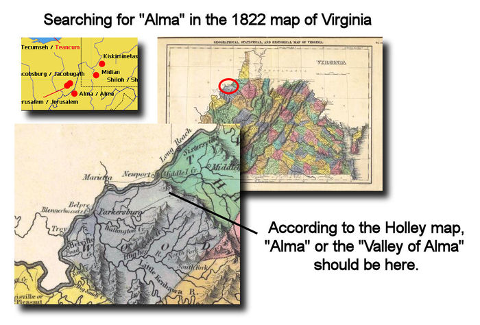
- Alma = Alma, Valley of—In the area indicated on the Holley map, modern maps show that there is a small, unincorporated community called Centerville, also known as Alma, in Tyler County, West Virginia, United States. Coordinates: 39°25′55″N 80°50′24″W. However, when we view the 1822 map of Virginia, we cannot find the name "Alma" anywhere.
- Antrim = Antum—"Antrim Township" is located in Franklin County, Pennsylvania. It was named after County Antrim in Northern Ireland. The township was organized in 1741.
- Antioch = Anti-Anti—The name "Anti-Anti" doesn't even appear in the Book of Mormon, nor does the biblical name "Antioch."
- Boaz = Boaz—The name "Boaz" is from the Bible. Joseph would not have needed to look at a map for this one, unless one accepts Holley's assertion that the Holley map is supposed to show the geographical locations of Book of Mormon places.
- Conner = Comner—The name "Comner" doesn't appear in the Book of Mormon. The name "Comnor" does, in Ether 14꞉28
. Of course, "Comnor" doesn't match "Conner" quite as closely in spelling. We cannot find "Connor" in either New York or Pennsylvania.
- Ephrem, Saint = Ephraim, Hill—The actual name is "Saint-Éphrem-de-Beauce, Quebec." Wikipedia shows the town being established with that name in 1866. This is 36 years after the publication of the Book of Mormon. The Book of Mormon name "Ephraim," of course, is easily found in the Bible.
- Hellam = Helam—According to their website, Hellam Township, Pennsylvania, was established in 1739.
- Jacobsburg = Jacobugath.—Jacobsburg, Belmont Co., Ohio does not even show up on a 1822 map of Ohio.
- Jerusalem = Jerusalem.—Jerusalem, Monroe Co., Ohio does not even show up on a 1822 map of Ohio. Even today the village of Jerusalem occupies only 0.2 square miles. Besides, the name "Jerusalem" is from the Bible. Joseph would not have needed to look at a map for this one, unless one accepts Holley's assertion that the Holley map is supposed to show the geographical locations of Book of Mormon places.
- Jordan = Jordan—The name "Jordan" is from the Bible. Joseph would not have needed to look at a map for this one, unless one accepts Holley's assertion that the Holley map is supposed to show the geographical locations of Book of Mormon places.
- Kishkiminetas = Kishkumen—Kiskiminetas Township, Armstrong County, Pennsylvania was given that name in 1832, two years after the Book of Mormon was published. From History of Armstrong County Pennsylvania, written in 1883 by Robert Walter Smith, "The petition of sundry inhabitants of Allegheny township was presented December 22, 1831, to the court of quarter sessions of this county, asking that a new township be formed out of the upper end of Allegheny township, to be called Kiskiminetas. Philip Klingensmith, John Lafferty and John McKissen were appointed viewers, who, after one continuance of their order, presented their report recommending the organization of the new township, which was approved by the court June 19, 1832." off-site Kiskiminetas River in Pennsylvania does exist prior to the town, and one would assume that it would show up on a map. The Holley map, however, does not indicate that Kishkiminetas is a river, but rather a place.
- Lehigh = Lehi—There is indeed a "Lehigh Valley" located in Pennsylvania.
- Mantua = Manti—According to their website, Mantua Village, Ohio, was incorporated in 1898. This is 68 years after the publication of the Book of Mormon.
- Monroe = Moroni—The author, in the next section, presumes that the name "Moroni" was derived from the capital city of the Comoros Islands, or from "treasure stories" about Captain Kidd. There is a town "Monroe, New York" which was founded in 1818.
- Minoa = Minon—According to the Minoa town website, the town of Minoa, New York received that name in 1895. That is 60 years after the Book of Mormon was published.
- Moraviantown = Morianton—Moravian Indian Reserve No. 47, Ontario, appears to have been established in 1782.
- Morin = Moron—According to Wikipedia, Morin Township, Quebec, was formed in 1852. This would be 22 years after the Book of Mormon was published.
- Noah Lakes = Noah, Land of—The name "Noah" is from the Bible. Joseph would not have needed to look at a map for this one, unless one accepts Holley's assertion that the Holley map is supposed to show the geographical locations of Book of Mormon places.
- Oneida = Onidah—See "Oneida Castle".
- Oneida Castle = Onidah, Hill—Oneida Castle, New York is located at 43°4′42″N 75°38′0″W. The town has existed since the 18th century.
- Omer = Omner—We cannot find "Omer" on any modern map of Pennsylvania, New York or Canada.
- Rama = Ramah—Rama Township, Ontario, was "first surveyed in 1834." [1] This is four years after the publication of the Book of Mormon.
- Ripple Lake = Ripliancum, Waters of.—Ripple Lake is so small that it is difficult to locate on modern day maps, and it is one of more than 250,000 lakes in Ontario. Are we to assume that Joseph selected this one location amongst many, and then converted the name "Ripple Lake" to "Ripliancum?"
- Sodom = Sidom—The name "Sodom," of course, is well known from the Bible. Joseph would not have needed to look at a map for this one, unless one accepts Holley's assertion that the Holley map is supposed to show the geographical locations of Book of Mormon places.
- Shiloh = Shilom—The name "Shiloh" is a biblical name. There is a Shiloh, Pennsylvania on modern maps.
- Land of Midian = Land of Midian—The name "Land of Midian" is from the Bible and it is located in Egypt. Joseph would not have needed to look at a map for this one, unless one accepts Holley's assertion that the Holley map is supposed to show the geographical locations of Book of Mormon places. We are unable to locate a "Midian" or "Land of Midian" on any modern map of Pennsylvania.
- Answer:
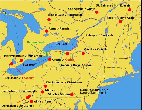
Not only are the names claimed to be similar to those in the Book of Mormon, but also that the locations of those names are similar. In addition, since some of these names could have easily been taken from the Bible instead of the surrounding region, one must assume that their inclusion on the map also implies that their geographical locations relative to one another are important.
- The author got one fact incorrect:
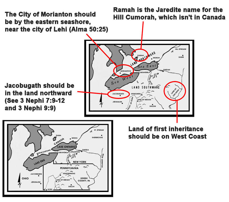
Looking at the geography, it is clear from Holley's map that a number of locations have been selected to make the names match the existing geography. Some examples:
- The map places Jacobugath, site of "King Jacob's" dissenters far in the land southward, when the Book of Mormon has it far in the land northward (3 Nephi 7:9-12; see also 3 Nephi 9:9).
- The map places the land of first inheritance [land of Lehi-Nephi] is on the eastern coast of the United States, while the Book of Mormon is clear that Lehi and his group landed on the western coast.
- The City of Morianton should be by the eastern seashore, near the city of Lehi (Alma 50:25).
- "Ramah" is the Jaredite name for the Hill Cumorah (Ether 15:11). The Hill Cumorah is not in Canada.
Summary: Vernal Holley has reconstructed a Book of Mormon geography based on a Great Lakes setting from the Book of Mormon text, which he then compares to the New England of Joseph Smith's day.
==
Notes
==
- [note] Reflections of the Past : the story of Rama Township : a joint project of the Township of Rama and the Orillia Public Library, off-site
